File:US Map-singlepartysenate.PNG
From Ballotpedia
No higher resolution available.
US_Map-singlepartysenate.PNG (513 × 333 pixels, file size: 36 KB, MIME type: image/png)
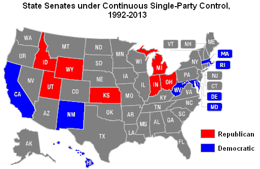
Map of state senates under single-party control from 1992-2013
you can send your inquiry to editor@ballotpedia.org |
File history
Click on a date/time to view the file as it appeared at that time.
| Date/Time | Thumbnail | Dimensions | User | Comment | |
|---|---|---|---|---|---|
| current | 05:00, 21 May 2013 | | 513 × 333 (36 KB) | Andymarshall (contribs) | Map of state senates under single-party control from 1992-2013 |
You cannot overwrite this file.
File usage
There are no pages that use this file.