Help us improve in just 2 minutes—share your thoughts in our reader survey.
File: U.S. Unified Command Plan Map 2008-12-23.png
From Ballotpedia

Size of this preview: 776 × 599 pixels. Other resolution: 1,600 × 1,236 pixels.
Original file (1,600 × 1,236 pixels, file size: 1.4 MB, MIME type: image/png)
Summary
| Description |
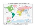
English: The world with commanders' areas of responsibility based on the Unified Command Plan 17 December 2008. (National Geospatial-Intelligence Agency map Edition 8 NGA Series 1107. |
| Date | |
| Source | http://www.defense.gov/pubs/pdfs/MAP12-08.pdf |
| Author | National Geospatial-Intelligence Agency |
| Other versions |
|

Licensing
This image is a work of the United States National Geospatial-Intelligence Agency or one of its predecessor agencies. As a work of the U.S. federal government, the image is in the public domain.
|
 |
File history
Click on a date/time to view the file as it appeared at that time.
| Date/Time | Thumbnail | Dimensions | User | Comment | |
|---|---|---|---|---|---|
| current | 04:57, 28 May 2009 | | 1,600 × 1,236 (1.4 MB) | wikimediacommons>Sv1xv | {{Information |Description={{en|1=The world with commanders' areas of responsibility based on the Unified Command Plan 17 December 2008. (National Geospatial-Intelligence Agency map Edition 8 NGA Series 1107.}} |Source=[[:File:U.S. Unified Command Plan Ma |
File usage
The following page uses this file: