Help us improve in just 2 minutes—share your thoughts in our reader survey.
File:Local I&R 50 states Map.png
From Ballotpedia
No higher resolution available.
Local_I&R_50_states_Map.png (509 × 581 pixels, file size: 58 KB, MIME type: image/png)
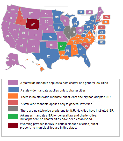
Map of 50 US states showing differences in state laws with respect to local I&R availability. Created on January 16, 2013
you can send your inquiry to editor@ballotpedia.org |
File history
Click on a date/time to view the file as it appeared at that time.
| Date/Time | Thumbnail | Dimensions | User | Comment | |
|---|---|---|---|---|---|
| current | 21:58, 16 January 2013 | | 509 × 581 (58 KB) | Geoff Pallay (contribs) | |
| 21:40, 16 January 2013 | Error creating thumbnail: File missing | 535 × 632 (61 KB) | Geoff Pallay (contribs) | Map of 50 US states showing differences in state laws with respect to local I&R availability. Created on January 16, 2013 {{BP logo}} Category:Laws governing local ballot measures, images |
You cannot overwrite this file.
File usage
The following 49 pages use this file:
- Laws governing local ballot measures in Alaska
- Laws governing local ballot measures in Arkansas
- Laws governing local ballot measures in California
- Laws governing local ballot measures in Colorado
- Laws governing local ballot measures in Connecticut
- Laws governing local ballot measures in Delaware
- Laws governing local ballot measures in Florida
- Laws governing local ballot measures in Georgia
- Laws governing local ballot measures in Hawaii
- Laws governing local ballot measures in Idaho
- Laws governing local ballot measures in Indiana
- Laws governing local ballot measures in Iowa
- Laws governing local ballot measures in Kansas
- Laws governing local ballot measures in Kentucky
- Laws governing local ballot measures in Louisiana
- Laws governing local ballot measures in Maine
- Laws governing local ballot measures in Maryland
- Laws governing local ballot measures in Massachusetts
- Laws governing local ballot measures in Michigan
- Laws governing local ballot measures in Minnesota
- Laws governing local ballot measures in Mississippi
- Laws governing local ballot measures in Missouri
- Laws governing local ballot measures in Montana
- Laws governing local ballot measures in Nebraska
- Laws governing local ballot measures in Nevada
- Laws governing local ballot measures in New Hampshire
- Laws governing local ballot measures in New Jersey
- Laws governing local ballot measures in New Mexico
- Laws governing local ballot measures in New York
- Laws governing local ballot measures in North Carolina
- Laws governing local ballot measures in North Dakota
- Laws governing local ballot measures in Ohio
- Laws governing local ballot measures in Oklahoma
- Laws governing local ballot measures in Oregon
- Laws governing local ballot measures in Pennsylvania
- Laws governing local ballot measures in Rhode Island
- Laws governing local ballot measures in South Carolina
- Laws governing local ballot measures in South Dakota
- Laws governing local ballot measures in Tennessee
- Laws governing local ballot measures in Texas
- Laws governing local ballot measures in Utah
- Laws governing local ballot measures in Vermont
- Laws governing local ballot measures in Virginia
- Laws governing local ballot measures in Washington
- Laws governing local ballot measures in West Virginia
- Laws governing local ballot measures in Wisconsin
- Laws governing local ballot measures in Wyoming
- Template:Laws gov map local IR
- Template:Local I&R map 50 states